Nature Notes: Speed Walker in the Dunes

If only Robert Moses, New York’s supreme 20th-century planner and doer, could revisit one of his first parkland acquisitions, Hither Hills State Park, and take a look as the gem of that park system, the Walking Dunes, he would feel very confident that his decision was well made.
The decision to purchase and preserve that land in 1926 must have been greatly influenced by the Walking Dunes and the woods and pristine pond beyond, not to mention the ocean and its white sand beaches. There were three walking dunes then. Lined up in a marching row southeast to northwest, they followed the track of the East End’s prevailing northwesterly winds.
The first was about to spill onto the Long Island Rail Road line, built a mere quarter of a century earlier. The second, close behind, and the third was just starting out and about to cover a handful of pitch pines standing in its way. The Walking Dunes were already desert-like enough to be used in the 1920s to film parts of the silent movie “The Sheik,” but they must have gotten a tremendous boost from the 1938 Hurricane, which destroyed Montauk’s fishing village on Fort Pond Bay, as well. In the last three decades, the dunes have moved forward only a few feet or so, but have maintained their impressive height along the leading edge.
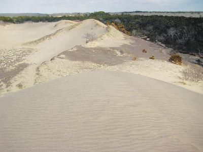
If only Mr. Moses could see them as they stand in March of 2013 he might be astounded. In less than two years, a fourth walking dune has crept in, and it is already taller than the other three. A week ago, Wednesday, while examining the long-standing cranberry bog with Karen Blumer and Vicki Bustamante, we were almost overcome. There it was, almost de novo, a new walking dune carved out of the sands of northeastern Napeague. It was a perfect parabolic dune, just as the others had been at one time.
The head of it was a smooth uplifted knob edged on both sides by swept-clean flanks of similar aspect and dimensions. Looking back from the highest point to the northwest, we saw a perfectly smooth bottom, devoid of any vegetation — a cradle as it were — which gave rise to the elevated cusp upon which we were standing. Except for our prints, which were being rapidly covered over by a stiff breeze, the knob, flanks, and belly were spotless, smooth, and all of the same off-white hue.
It was only a nubbin when we last visited the bog in September, now it was a full-fledged “walking dune,” marching forward double-time. Since it formed on the Napeague Harbor side of its older sibling, it will not overtake it or fill it in, but at its current speed, it should push forward of it in a matter of a few years. Its roommate has almost stopped dead in its tracks, as its belly has reached groundwater and is fully grown over with cranberries, other wetland plants and a few young pitch pines, browned over by Sandy’s wrath. There is very little dry sand that is not tied down by vegetation to feed its continued movement.
Myron L. Fuller and other early geologists who studied Long Island’s dune system were duly impressed by how much some of the dunes had moved. In East Hampton Village, dunes from the east side of Georgica Pond migrated inland more than a mile to beyond where the railroad tracks now run. From Two Mile Hollow Beach, where the road by the same name runs, dunes migrated all the way to where the railroad tracks and Springs Close Highway meet.
These last two sets of dunes were spawned by southwesterlies pushing ocean beach sand inland. The walking dunes are moving Napeague Bay sand in the other direction.
On the north side of Montauk Highway, along the middle of the Napeague isthmus, are a bunch of isolated hillocks rising up from the wetlands there. They were also moving inland from Napague’s ocean beach sands, but they were stopped in their tracks long before the road and the railroad to Montauk were constructed. It’s tough going for a dune to travel over wetlands, particularly so when it’s being pushed by northerlies in the winter and southerlies in the summer. It ends up going nowhere.
The Napeague isthmus was formed only a few thousand years ago by the re-entrance of eroded sands drifting and blowing shoreward to it from the morainal bluffs in Montauk and Amagansett on the east and west. Geologically it is relatively young.
There’s a strong probability that in less than 100 years Napeague Harbor’s water level will rise to the degree that it fills in the Walking Dune swales and even reaches beyond to Fresh Pond in Hither Woods. The landscape on the East End is always changing, and as long as we have Irenes, Sandys, and ferocious northeasters, it always will. That’s one of the great delights derived from living here and having the nail-downed concreted-over great city of New York 100 miles in the distance.
