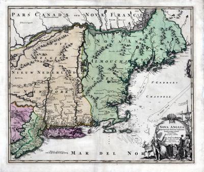
Johann Baptist Homann Map of New England, c. 1716

If you consider yourself a map aficionado, then you will be excited to learn that the East Hampton Library’s Long Island Collection acquired two new maps last month. The first is Nova Anglia Novum Belgium et Virginia, a 1637 map of the East Coast of North America (from the Carolinas to Nova Scotia), by the Dutch cartographer Johannes Janssonius (alternately known as Jan Janssonius or Jan Jansson).
It is believed that Janssonius’s map relied on an earlier 1630 map by Dutch geographer Joannes de Laet, which is considered the source map for New England and the Northeast, being the first to name Manhattan, New Amsterdam (New York City), and Massachusetts in any form. Both maps gave the best depiction of the coastline for the time period and are some of the earliest maps to record English settlement in New England and Dutch settlement along the Hudson River.
The second map, shown here, is Nova Anglia Septentrionali Americae implantata Anglorumique coloniis florentissima, by the prominent German geographer and cartographer Johann Baptist Homann. This 1716 map of New England, New York, and New Jersey actually covers a wider area, ranging from Canada to Delaware Bay, and from Philadelphia to Nova Scotia.
The map also identifies both European and Native American settlements through the use of drawings or circles, as well as depicts depth soundings, shoals, and banks significant for maritime travel along the coastline. In the drawing in the bottom right-hand corner, one sees a European merchant trading rifles, tools, and other goods with a Native American man for beaver pelts. The North American fur trade, which reached its height in the 19th century, became one of the main economic objectives in North America and was the driving force behind both settlement and trade in 17th and 18th-century New England. The map, like many early examples, is not without its errors, but is considered a significant piece of cartography.
—
Gina Piastuck is the department head of the East Hampton Library’s Long Island Collection.
