AVIATION: A Close Eye on Airport Traffic, Town board agrees to buy a new weather system for 'safer' flying
The East Hampton Town Board heard a report from its airport manager on its new aircraft tracking system on Tuesday. It also agreed to buy a $65,000 weather observation system. That system would make the airport "safer," the manager, Jim Brundige, said, and would allow him to report certain violations to the Federal Aviation Administration.
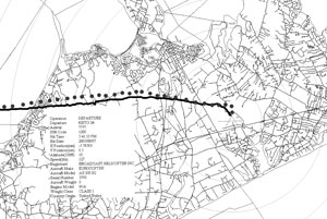
The $325,000 tracking system, installed at East Hampton Town Airport in May, provides Mr. Brundige with the route and altitude of each and every helicopter or plane that flies in and out of the airport, to a distance of about seven miles.
The system can also read the aircraft identification numbers of newer planes. Older planes that lack transponders can be identified by correlating the tracking system information with airport logs.
The purpose of the system is to determine if aircraft are complying with voluntary noise-abatement procedures the town has asked pilots to follow. East Hampton Town bought the equipment after a growing number of residents pleaded with officials to do something about airport noise.
The system includes four antennas placed within a five to 10-mile radius that relay information to the airport, and one antenna at the airport itself.
Based on the data recorded, the system can generate maps showing the routes of every aircraft that flew to and from the airport on a particular day. Detailed information, such as the plane make, model, serial number, weight class, time, altitude, and country of origin, can be generated with the click of a mouse.
East Hampton Airport, Mr. Brundige told the board on Tuesday, is the only airport of its kind with a tracking system so sophisticated. Other airports where it is used, he said, include Logan Airport in Boston, McCarron Airport in Las Vegas, and Narita Airport in Tokyo.
While the town cannot impose flight regulations on pilots, it has requested voluntary compliance with recommendations designed to minimize disturbance to residents from aircraft noise, particularly helicopters.
The recommendations, published in the airport manual used by pilots, include limits on operations between 11 p.m. and 7 a.m. and a request that helicopters use one of two designated approaches, one from the north and one from the south.
The flight tracking system has shown that most aircraft are following the recommendations, at least loosely. But the southerly approach has generated complaints from residents of the Rose's Grove and Millstone Road areas near Noyac and Bridgehampton.
The system, Mr. Brundige said yesterday, "gives me an overall picture of what's going on out over the population, and has allowed me to redesign the recommended routes."
He suggested eliminating the route from the south that had drawn complaints, and board members agreed with him. Pilots will be advised of the recommendation.
Aircraft operators who don't follow the town recommendations receive a letter from Mr. Brundige along with a copy of the tracking data and his observations, a copy of the town's voluntary noise abatement procedures, and a request that they comply with them.
Mr. Brundige said he has told New York State Senator Charles Schumer, who recently suggested that the F.A.A. rerquire helicopters to fly primarily over water in the New York and Long Island area, that flight routes are not as crucial as altitude.
While the F.A.A. imposes a minimum flight altitude of 1,000 feet for fixed-wing aircraft, there is no minimum height for helicopters. East Hampton has asked helicopter pilots to fly at a minimum altitude of 2,000 feet.
Also on Tuesday, the town board agreed to purchase an automated weather observation system that will allow pilots to use instrument landing systems.
Without the system, Mr. Brundige explained, pilots must fly low enough to see the runway, thus creating more noise and a safety risk, especially on overcast days. "They fish their way around and find the airport," he said. "I don't think it's very safe."
The F.A.A. says that pilots can land at airports that lack weather observation systems if they have one mile of clear visibility.
If East Hampton were to install a weather observation system, the airport could apply for a new F.A.A. classification that would trigger regulations requiring pilots either to have three miles of visibility, or to use an instrument landing approach. Mr. Brunige could then report violations to the F.A.A. rather than send pilots a letter requesting compliance.
Using the system is a "much safer, higher altitude situation," Mr. Brundige said. "We're really behind the curve on this; we're about the only airport in this country that doesn't have this."
The cost of the weather system is estimated at $65,000. Councilman Pete Hammerle said that a private resident who owns a plane had offered to contribute a system or pay for it outright. The town will buy the system itself, he said, but could then accept private contributions toward the cost.
Supervisor Bill McGintee said that he would like the public to have access to the airport's weather information. He explained that businesses could benefit if tourists could check the weather in East Hampton before visiting.