Map of Historic Sites Nears Completion
The perfect companion to East Hampton's tricentquinquagenary - a map pinpointing and describing the town's important historic sites and landmarks - is on its way to the printer. The map, which depicts everything from the tiny Dominy family cemetery to the 1898 debarkation point for Teddy Roosevelt's Rough Riders, will be ready for distribution in about two weeks.
Streetwise Maps, a worldwide operation with headquarters in Amagansett, drafted the map pro bono, with input from the East Hampton Historical Society and other groups. The Suffolk County National Bank is underwriting the printing.
"It's completely ready to go" to the printer, said Streetwise's president, Michael Brown. "I think we're all pretty happy with it."
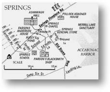
The "Historic East Hampton" map resembles Streetwise's popular laminated street map of the town, which was released in 1994. Historic sites are superimposed in the form of icons and even line drawings of landmark buildings. Detailed inlays of East Hampton Village, Springs, and Sag Harbor are included, along with the sites of notable shipwrecks off the town's shores, dating back to the H.M.S Culloden in 1781.
Mr. Brown said he had gotten an education in the mapmaking process. "I've lived out here for seven years, and there were a lot of things I didn't know about. It was nice looking at the history of East Hampton as opposed to the straight-ahead fact-checking on street names and other things I normally have to do."
Bruce Collins, who chairs the 350th Anniversary Committee, said the map was "something the whole committee thought would be nice to do." Two committee members, Barbara Borsack and Stuart Epstein, took charge of the project.
"I think [Streetwise] did a very nice job," said Mr. Collins. He predicted a long life for the map. "It's a functional thing that people will be able to use for a long time. It's going to be one of those things you can stick in your glove compartment and use as a reference."
Suffolk National's donation of the printing costs "helped us dramatically," Mr. Collins added.
The map will cost $7.95. It will be available at the anniversary committee's headquarters at the East Hampton railroad station and at the Historical Society's offices in the Osborn-Jackson house on Main Street, among other locations.