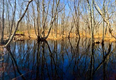
Nature Notes: The Kettleholes

Long Island is an island. More than 450 years after its naming, following its discovery by Columbus, and at least 200 years after geologists said so, New York’s highest court decided that it was indeed an island. But it’s not the only Long Island in America; there’s one on the upper Pacific Coast and no doubt others, should one study the maps closely.
Its salient geologic features are its beaches, its coastal bluffs, especially on its north side but also on its south along the hamlet of Montauk, its dunes, soils, its water courses, not to mention its varied ever-changing vegetative covering.
Because Long Island was largely created by the visitation of glaciers, it is also differentiated from more southern coastal areas by the presence of glacial erratics and kettleholes. Glacial erratics are the large boulders, some more than 50 feet in diameter and elevation, that sit along the North Shore and the northern part of the South Shore, especially on the South Fork. Kettleholes dot the landscape wherever the glacier visited, again, on the South Fork we are rich with them.
The term kettlehole is a vernacular word that is solidly implanted in the geologic scientific literature in the same way as “erratics” and “hoodoos,” those ocean-fluted bluffs situated between the Montauk Lighthouse and downtown Montauk. Montauk is rich in all three. Montauk is also one of the few spots on Long Island that has two layers of fresh groundwater — one that is more or less permanent that bottoms out near sea level, another well above sea level, with a surface only a few feet below grade depending upon location. This upper soil water layer rests on clay lenses and comes and goes depending on the amount of rainfall in a given year.
Most of our ponds that are roughly bowl-shaped are kettlehole ponds. There is a well-traveled road that runs from west to east through the Bridgehampton and Water Mill farmlands called Scuttlehole, an obvious corruption of kettlehole. Shorts Pond, a classic kettlehole pond, sits immediately to the north of it, just east of the Atlantic Golf Course in Bridgehampton.
Kettleholes were formed by large chunks of ice that sat on the ground and melted during the glacial retreat. As they did so, the sediments they contained accumulated mostly on their edges. The combination of jettisoned sediments and an ice block’s weight created the bowl-shaped depressions, which retained most of the meltwater left behind.
One of New York State’s most renowned botanists, Norman Taylor, came to Montauk to study its flora in the early 1920s. He spent a lot of time studying Montauk’s kettleholes, because they contained so many plants, both aquatic and wetland ones and, farther up the side, terrestrial ones. Almost all of the kettleholes he studied still exist today, and despite the fact that their original floras have been somewhat bastardized by the introduction of such exotic plants as mile-a-minute weed, Japanese knotweed, mugwort, and phragmites, they are still flourishing.
When I taught ecology at Southampton College in the 1970s, the textbook I used had a big section on plant succession, a classic example of which is the change in a dry kettlehole’s flora over time, especially as it fills with more and more water and becomes a pond. That is happening today at an accelerated rate, especially in coastal ponds, as the fresh groundwater is buoyed up by denser salt water below, the level of which is elevating a few millimeters a year as sea level rises.
A dry kettlehole, of which there are still several around, especially in the moraine, takes on water every time it rains but most become dry again as the water percolates down through the kettlehole’s porous bottom. Kettleholes that barely sit above an aquifer that is slowly rising will take on water as the groundwater rises. The dry soil plants are gradually replaced by wetland species, then by pond species as the filling increases.
In Wainscott, north of Daniel’s Hole Road and next to a small subdivision, there is one of these nameless deep kettleholes, which is filled with more and more water with each passing decade. There are several such holes that are beginning to become wet throughout Hither Woods in Montauk. In droughts, such as the record ones in the 1960s, some kettleholes lost all their water and did not fill again until rainy years. One of these is Little Poxabogue Pond in Sagaponack.
In the older textbooks, such kettleholes would ultimately become dry as they became occupied by trees; the trees used up more water than the rainfall provided. On Long Island with normal rainfalls and with the water table so close to the surface throughout so much of the area, such cases of a wet kettlehole reverting to a dry one will be very rare.
There is a very large, mostly unexplored kettlehole in northern Montauk off Kettlehole Road, east of Fort and Tuthill Ponds and west of Culloden. It is very deep, quite overgrown, and, as far as I know, has hardly been explored. If I were younger I would dive in. Perhaps one of those budding naturalists in the Third House nature group will do it for me — before it fills with water!
Larry Penny can be reached via email at [email protected].
