Nature Notes: Spoiling Havens

The Village of Sag Harbor is more of a harbor municipality than a beach haven. There are beaches on all sides, Long Beach on the west and Ninevah beach on the east near the East Hampton Town line. My tax map book for Sag Harbor shows a possible East Hampton ownership tag for the outer beach sands lying between Sag Harbor’s Havens Beach Park and Northwest Harbor. The dredge spoil deposited on Havens Beach in the spring of 2018 was full of a bunch of curiosities including pieces of concrete, crockery, rusted hunks of metal, and other junk. The beach became more of a junkyard than the sandy beach it was prior to dredging.
Suffolk County did the dredging, but the work, which should have been screened by the village’s harbor committee, didn’t really have an overseer, or it would have been stopped shortly after it started. Apparently the collection of stuff from the harbor floor was not properly screened, thus accounting for the various largish objects and blackish underlay that now makes up a good part of the beach.
A Havens Beach group formed as a result of the strange collection of materials and this group gave an eye-opening presentation replete with maps and narrations to a packed house at the recently redone Sag Harbor Library last month.
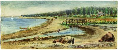
There were three presenters, Carol Williams, Jean Held, and Terry Sullivan, all of whom were regulars at the beach for a long time before the dredging. The slide show featured early photographic representations of Havens Beach, as well as an early landscape painting done by a resident of Sag Harbor, the late Annie Cooper Boyd, in which a small stream by the name of Little Creek could be seen as it went through the marsh that was once a large part of the Havens Beach Park parcel. Thus, there was once a third creek entering the headland of Northwest Harbor in addition to Little Northwest Creek, which separates Sag Harbor from East Hampton and Northwest Creek, the largest of the three.
Little Creek and the salt marsh that surrounded it are no longer, having been filled in with sand and other soil materials over the course of the 20th century. I looked on one of my historical United States Coast and Geodetic Survey maps, dated 1888, and sure enough, Little Creek and the salt marsh were still extant, if not in name, at least in substance, as of that year. Instead of Little Creek, now there is a longstanding man-made ditch that collects rain runoff from a fairly large watershed basin on Sag Harbor’s east side and shunts it through a pipe under Bay Street out into Northwest Harbor. Unfortunately, the culvert under the road is too small to pass all of the water through in a timely fashion and after a large rain or snow melt the water backs up and floods nearby basements and yards.
One of the saving graces of the eastern portion of Havens Beach Park, which was spared from the corrupt dredge spoil, is a large, partially vegetated sand-filled area where gulls, fish crows, some shore birds, and other bird species gather from time to time.
Before the dredging, the beach was a popular area for local dogs to not only visit, but also to defecate, to the degree that one smelly eyesore was replaced by yet another, or, maybe, there are two smelly eyesores present now instead of one.
It is still a mystery why the harbor had to be dredged at all by Suffolk County’s Department of Public Works. Some postulate that it was dredged to accommodate bigger boats with bigger and deeper hulls. Part of Sag Harbor’s fascinating history is its harbor, which has earned quite a reputation in the past for accommodating big boats, ships, even. It was the first customs port in New York State and one of the East Coast’s biggest whaling ports during the 1800s.
Larry Penny can be reached via email at [email protected].
