New Views Of Montauk’s Wonders

Large shad, their trunks corkscrewing skyward, quartz crystals sprouting from lichen-covered glacial erratics, tight stands of tupelos, the swamp-loving tree, large oaks and silver-barked beech overseeing their proprietary clearings, dense networks of denuded limbs in the surrounding understory, kettle holes, homes to sleeping newts and salamanders, canopies of hollies arching over the trail at points — are what hikers have come to expect from a winter afternoon spent on many of Montauk’s trails.
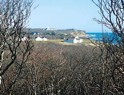
Along with these wonders, trails recently cut within the 200-acre Amsterdam Beach Preserve have brought into view several natural sanctuaries, large depressions, tree-covered glacial slumps that fall away from the trail in places to reveal the hills and dales that in days of old were often bare but for waves of maritime grass.
In the unseasonable warmth of New Year’s Day, the meandering Amsterdam Beach trails were alternately sunlit and tree-shadow dappled. Coats were shed, caps removed.
The preserve, an area of what has long been referred to as the Montauk Moorlands, was created starting in 2006 by the Nature Conservancy, with money from town, county, state, and federal governments. The preserve grew in size two years later when Dick Cavett sold 77 acres of contiguous land to the Conservancy.
The rolling expanse stretches from Ranch Road at Indian Field on the east to the Montauk Association houses (seven “cottages” designed by the firm of McKim, Mead, and White in the 1880s) to the west. It is bordered on the north by Montauk Highway and extends southward to the Atlantic Ocean.
Speaking of which, when following the slow meander to the south, a hiker is tantalized by glimpses of the blue briny through the trees when the trail rises to the surface of the bramble. Then, it’s back down again into the holly and up again for a peek at the ocean before heading below on a switchback until finally hikers are delivered to the bluffs where they meet a vast panorama. To the east is the Montauk Lighthouse with Block Island in the distance. To the west the grand association houses seem to float in a rolling sea of gray bramble. Before you, the sea stretches Hampton Trails Preservation Society has honchoed the trail work with help from state park employees and a legion of volunteers. Mapping the trails began last winter when Scott Wilson and Andy Gates from the town’s Department of Land Acquisition and Management crawled around the preserve with global-positioning-system devices seeking higher, trail-worthy ground.
“A lot of it is perched wetland,” Mr. Poveromo said on Tuesday by cellphone as he and volunteers continued to remove stumps from the trail. “We flagged their GPS points and got in there with chain saws and axes. There are not a lot of alternative routes.”
Clearing the trails mapped by Mr. Wilson and Mr. Gates began in earnest in early November. “We have been coming back every Tuesday and alternate Saturdays and Sundays. There’s been six to eight people every day,” Mr. Poveromo said, adding that the few bridges and boardwalks needed to traverse wet spots would be built with money included in the town’s 2012 budget.
The Amsterdam Beach trail system is composed of the new trails that join much older ones whose derivation was a mystery, Mr. Poveromo said.
“Did you see the holly arbor?” he asked. “This place is something you don’t find anywhere else. To see this, you have to be here. It’s not even work,” he said of the trail clearing. “It’s a labor of love.”
