Record Rains Here Caused Floods, Erosion-The heaviest steady downpour in a century
It seemed as if it rained 40 days and 40 nights last week, 18.13 inches in eight days - the most in a century during a single storm on the South Fork. If bucket brigades, round-the-clock basement pumping, and housebound people and pets qualify as ark construction, then hundreds were in the works by Saturday.
Despite winds that gusted to 50 miles per hour, it was not the ferocity, but the long-winded nature of a stalled weather pattern that caused flooding from New Jersey to New England, and filled cellars, roads, and ponds here.
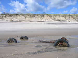
The rain that fell steadily from Oct. 7 to early Saturday morning greatly accelerated erosion on both the ocean and bay sides of the South Fork. Steady winds of 25 miles per hour and higher drove surf and tide east to west along ocean and bay beaches.
From Montauk to Sagaponack, much of what is left of the ocean dunes was saturated by the rain, making it even easier for wind-driven surf and full-moon tides to consume them. To the east at Montauk's Ditch Plain Beach, the primary dunes were hit hard.
They are the only features blocking the ocean from making a downhill run through a low-lying community to Lake Montauk. According to the East Hampton Town Department of Natural Resources, as much as 24 feet of dune were lost in at least two places where surf pounded, at the same time as water from a flooded wetland attacked the dunes from the landward side.
Once again, the ocean drew close to Montauk's beachfront motels when fierce east winds, waves, and especially high tides carved sand away to within a few feet of the buildings' foundations.
Flooding was the worst in memory. In Sag Harbor severe flooding took place in the area of upper Glover Street at Redwood and the sump behind Rogers, Latham, Division, and Henry Streets. The village's sewer system nearly overflowed, a problem that was exacerbated when a few Main Street merchants pumped out their basements directly into the sewer system, according to authorities. In all, 293,000 gallons had to be pumped from the treatment plant into tanker trucks to keep effluent from entering the harbor itself.
A large section of the soil cover that drapes the East Hampton landfill on Springs Fireplace Road became saturated and sloughed off.
Residents of the communities surrounding Georgica Pond reported the highest pond levels in memory, a fact verified by East Hampton Town Trustees who ordered the pond opened on Tuesday afternoon. That was much too late in the opinion of Kevin Mulvey, a resident of Chauncy Close. "Gross negligence," is how he characterized the trustees' slow response to the unprecedented rain. Mr. Mulvey said he had to stay awake night and day to keep his basement pumps working.
If the wind had come from the southeast instead of the northeast, erosion on the ocean side probably would have been worse, although a southeast wind might well have opened the narrow sand dam that separates Georgica Pond from the sea. Even before Tuesday's letting, sand from a flat near the pond's mouth was reserved on behalf of beachfront homeowners in Wainscott and Sagaponack who are in danger of losing their homes. Up to 6,000 cubic yards of sand will be excavated and trucked west within days.
Larry Penny, East Hampton's director of natural resources, said that his department, like its counterpart in Southampton, was flooded with applications for emergency permits to control erosion. "And this is only the beginning," Mr. Penny said.
Mr. Penny said he was going to recommend that motel owners and others fearful for their property consider using the same, large canvas bags filled with sand that were used to repair the New Orleans levees that broke following Hurricane Katrina. Mr. Penny said that with winter storms not far off, the bags would probably be acceptable to the State Department of Environmental Conservation as an emergency stopgap measure.
During a meeting of the East Hampton Town Board on Tuesday, Supervisor Bill McGintee announced that the town would try to expedite the D.E.C.'s permit process for those needing to rebuild dunes. Damage must be documented by the Natural Resources Department.
A high dune just west of Beach Lane in Wainscott was badly scoured, leaving a staircase dangling in the air. In nearby Sagaponack, the ocean drove its way right up to the Town Line and Gibson Beach Road ends. Billy Mack of the First Coastal Corporation, coastal engineers, said that about 40 feet of dune were lost. Dune Road in Bridgehampton was overtopped.
"We're working on about a dozen calls for emergency sand. We have enough, but it's too risky to put it in some sections because the beach is too narrow. It would just get washed away. We have to time it," Mr. Mack said.
Gary Ireland is a lawyer who has sued the Army Corps of Engineers and the county to have three rock groins in East Hampton shortened, or removed, and the stretch of beach between them and Sagaponack rebuilt. It is an accepted fact that beaches located downdrift from hard structures such as groins and jetties are subject to scouring.
"I've been telling people to call their senators. Mathew Cohen is Senator Charles Schumer's aid, and Rasi Cooper, Senator Hillary Clinton's assistant. Tell them we appreciate the [Army Corps of Engineers'] studies, but we need a project. We know the cause of the erosion. It's the groins in East Hampton. The towns are going to be inundated with applications for bulkheads, rocks. Until the beaches are nourished, you can't blame people. They have to see a solid beach in front of them," Mr. Ireland said.
At the same time that sand was taken away by waves and tide, it was also collecting in the Accabonac Harbor inlet, making it nearly impassable. On the inlet's south side, erosion cut Louse Point back to the beach parking lot. On the north of the inlet, waves overtopped Gerard Drive, and the new culvert under the drive was clogged with sand and stone.
On the bay side of Montauk, the Soundview community west of the harbor inlet took its usual beating. Farther west, 150 feet of bulkheading collapsed on the Clearwater Beach side of the Hog Creek channel.
Michael Wyllie of the National Weather Service laboratory in Upton explained the cause of all the wind and rain. He said that beginning on Oct. 7, a subtropical system took up residence close to Bermuda. A rare "inverted trough" grew from there into the northeast. The trough was kept in place by a high pressure system located off the coast of New England.
As a result, a series of low pressure systems moved southeast to northwest along the boundary of the trough, creating the tropical rains. "One of the lows was strong enough to create winds between 30 and 50 miles per hour," Mr. Wyllie said.
Richard Hendrickson, who keeps local statistics for the weather service, said the rain started on Oct. 7 and continued every day until Saturday morning. The heaviest downpour occurred on Friday, 5.69 inches. The next day, it rained 4.32 inches before the storms finally passed.
The total was 18.13 inches, according to Mr. Hendrickson's gauge in Bridgehampton. It was a record for a single storm according to the weather service's records from 1900 to 1917, and from 1930 to the present day. If more fell during the 13-year gap in the records, we will never know.