Recreation: A Blueprint
Looking into the future, a citizens committee working with the East Hampton Town Planning Department has drawn up a long list of what it calls "opportunities" to enhance recreation in the town, with a special focus on the waterfront.
The list includes 11 new accesses to the water, a park complete with a swimming pool, tennis and basketball courts, a Rollerblade run on town-owned land near Montauk's recycling center at the eastern edge of Hither Woods, and other pools at Maidstone Park in East Hampton and at Camp Hero in Montauk.
Access, access, access is one way to sum up the recommendations in a comprehensive report on recreation that the ad hoc committee to develop a Local Waterfront Revitalization Plan has completed.
Project And Policy
The 100-page report was discussed at a special meeting of the Town Board on Sept. 25 and will be presented to the public at 4 p.m. on Friday, Oct. 18, at Town Hall. The recommended accesses to the waterfront are mostly for pedestrians and would require the purchase of land.
Copies of "Recreational Resources - Inventory and Analysis and Policies" are available at the offices of the Town Clerk or Planning Department. The report is the latest segment of the Waterfront Revitalization Plan, which is being done in compliance with state guidelines and with state funding.
Rameshwar Das, a Springs activist who chairs the citizens committee, described the new report as more "project oriented" than "policy oriented." He said he considered the 11 additional accesses recommended "a relatively small number."
Concern Described
"We were more concerned with cleaning up, or opening up, those that have been closed off unnecessarily. As an example, he noted a sign placed in front of an access to the water at Lazy Point in Amagansett that reads "private property" when "it's not."
Lisa Liquori, town planning director, said this week that the larger projects in the report, such as the one near the Montauk recycling center, should be seen as "generalized opportunities."
For more to happen, you would have to have a "site-specific plan, a feasibility plan, perhaps a grant. There is no time-frame," she said, observing that the development of the former Montauk landfill, though town-owned, would be restricted by the state for the foreseeable future.
Buses To Beaches
During the Sept. 25 presentation, Supervisor Cathy Lester and Ms. Liquori agreed that many of the town's beaches were lacking in public access.
"This report lets people know what accesses there are, and it will help figure out alternative plans," said Ms. Lester.
Although the report recommends buying land for additional parking at some beaches, Ms. Lester said that in the long run shuttling people back and forth to public beaches would be preferable to paving over beach and dune land for parking.
Town Councilman Tom Knobel pointed out that the report did not resolve the issue, however.
Legal Constraints
Ms. Liquori said later that the busing-rather-than-paving suggestion was a policy born of legal constraints. She noted that the United States Supreme Court had made it clear that private developments were not required to provide public access to public lands, such as beaches and harbors.
The report divides the town into 12 reaches, as was done for the plan's segment on flooding and erosion, and it identifies existing resources and opportunities in each of them.
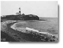
In the Montauk Bluff reach, for example, the report recommends public acquisition of two beach accesses - one at Camp Hero, the other in the Sanctuary development. For the area around the north end of Lake Montauk a need is seen for better pedestrian access to the Town Dock and all along the docks - at Montauk Fish Dock, Tuma's Dock, Salivar's, the Viking Dock, and on around through Coon's Foot Cove.
Shadmoor Access
Public access should be acquired at Shadmoor, the report states, and Rheinstein Park needs its wetlands restored. The report suggests additional parking and toilet facilities, among other amenities, for town land at Navy Road and states that the public needs a way to walk to the beach at Culloden Point.
On Napeague's north side the suggested improvements include a canoe-kayak campsite at Hither Hills near the Walking Dunes. The launching ramp at Napeague Harbor Road needs fixing, and toilet facilities are needed on Trustee-owned land at Lazy Point.
On the ocean at Napeague, the report recommends the purchase of land for public access at Sea Breeze Estates, near the Lobster Roll restaurant, and parking, bike racks, and toilet facilities for town land formerly owned by the Church of God.
Other Accesses
At the Double Dunes Preserve at Bluff Road, Amagansett, additional land should be purchased, or easements obtained, to create a contiguous ecosystem.
In the area of Accabonac Harbor, wetlands and the launching ramp at Landing Lane Road need restoration. Bike racks are recommended for Gerard Point and Louse Point.
A new pedestrian access is recommended on the west side of Three Mile Harbor at Hedges Banks Drive. The road end at Old House Landing Road needs to be restored, and a path near Springy Banks Road needs an access for off-road vehicles. In addition to a swimming pool at Maidstone Park, it could accommodate tennis courts.
Public access should be acquired at the Hopping parcel on Georgica Pond, and at Mathews Road there, and a launching ramp is suggested for low-draft boats onto Georgica Pond at the state access at Montauk Highway.Also listed among improvement opportunities are parking and wetland restoration at Cedar Point Park, and the elimination of phragmites in Alewife Pond.
Beach-Driving Bias
At the Sept. 25 meeting, Councilman Knobel said the report showed a bias against beach driving. Mr. Das and Ms. Liquori denied such a bias.
"We're not intending to tell the board what to do. What we did note is what's on the books, and where it doesn't jibe with what's on signs et cetera," said Ms. Liquori.
Throughout the report, there are recommendations for amenities such as benches, picnic tables, bicycle racks, and the like. The report considers "water-dependent" recreation, such as boating and swimming, and "water-enhanced" ones, such as trails, golf courses, and tennis courts with a water view.
A section deals with hunting and fishing, and multiple-use problems are identified for each location, as are environmental concerns and those recreational uses that are considered compatible with new private development.
Potential Conflicts
Two kinds of conflicts also are identified. One type is between different kinds of recreational uses. The other kind of conflict is between the desire for recreation and access to it and the need to protect the resources that provide it.
Listing existing and potential conflicts was important, Ms. Lester said on Sept. 25, because someday, "We will need to say which is the highest and best use." Jet Skis were given as an example of an activity which many see as interfering with swimming, boating, and fishing.
When launched over 10 years ago, the Waterfront Plan included six separate focuses of study: fish and wildlife habitats, flooding and erosion, public access, scenic and historical resources, air and water, and development policies. Since then several areas of concern were consolidated.
Flooding And Erosion
The need for new policies to deal with flooding and erosion to better address the increasing number of applications for bulkheads and other approaches to erosion control got priority. This section of the plan is the only one so far to have been the subject of a public hearing. It took place in August.
A second meeting at which amendments to the report could be approved, the adoption of a final version, and the drafting of laws based on that version are supposed to be part of the process. It was noted, however, that the work of this section of the plan was completed during a Democratic administration, while the Town Board majority, which has been Republican since January, could be expected to seek its re-examination.
Toward New Laws
Supervisor Lester began the Sept. 25 meeting by announcing she would like the town attorneys to begin drafting laws to implement the flooding and erosion recommendations. "Let's move along, the Zoning Board of Appeals has the need," she said.
Ms. Liquori said turning recommendations into law was a prerequisite to state review, and state approval of the entire plan was the goal. She said planners and the committee hoped to finish all components of the plan by the end of the year.
Meanwhile, Councilman Knobel informed his colleagues that the Town Trustees were about to release their proposal, which they are calling a "manifesto," for supplanting the Z.B.A. in waterfront areas.
"They are concerned the Local Waterfront Revitalization Plan will take them out of decisions," Mr. Knobel said. "You have to decide what to do about them before the flooding and erosion plan is adopted," Mr. Knobel said.
The next sections of the plan to be addressed are those dealing with flora, fauna, and fisheries. A special meeting to present these to the Town Board will be held at Town Hall on Oct. 28 at 10 a.m.