Sagaponack Village Is Still in Limbo-Boundaries have become ambiguous as a hamlet begins incorporation process
When Carlton M. Strong's family chose to send their children to the Wainscott School because it was closer to their farm on Town Line Road than the Sagaponack School, they had no idea that a century later a Village of Sagaponack might exist and that their decision might complicate its incorporation plans.
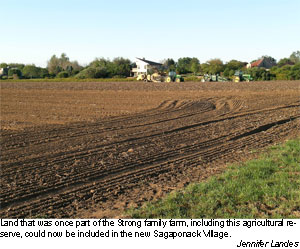
The village's proposed boundaries are the Sagaponack School District, which the Towns of East Hampton and Southampton as well as Suffolk County and the state have long recognized in maps as excluding the original boundaries of the Strongs' farm. The approximate area is west of Town Line Road from Parsonage Lane to just south of Hedges Lane with the Jacobs Way subdivision as its western boundary.
The family as well as the residents of the subdivided parts of their original property are on the tax rolls of the Wainscott School District. Portions of the property dedicated as agricultural reserve and now owned by the town are not taxed.
The 27 households, while considered residents of Sagaponack and the Town of Southampton, were not allowed to vote for the incorporation because they are not included in the official maps of the school district. The organizers of the incorporation drive said they chose the established district boundaries to best meet the state incorporation law requirement of "common certainty" about their location and extent.
Marietta Seaman, the Southampton Town clerk, sent the school district map to the New York secretary of state as part of the report of incorporation she was required to file after the residents of the school district resoundingly voted in favor of becoming a village on Sept. 2 and the vote went unchallenged 10 days later. The report also included the certificate of election and the population of the new village.
Larry Sombke, the assistant secretary of state for communications, said that when the Department of State received the report, Ms. Seaman was told the state required a written description of the village boundaries, or "metes and bounds," to be filed prior to issuing a certificate. The department is "awaiting the submission of the required documents" and the certificate is pending, Mr. Sombke said.
The town quickly hired Squires, Holden, Weisenbacher, and Smith, Land Surveyors, to write and research the description that was sent Monday, according to Acting Deputy Town Attorney Kathleen Murray. A resolution to pay the firm $7,500 was passed on Tuesday night by the town board.
The written description of the new village boundaries, however, contains a western boundary that runs down Town Line Road from Montauk Highway to the "high water line of the Atlantic Ocean." This includes the Strong farm and the 27 properties into which it is now divided. Ms. Murray said that Karl Weisenbacher, who signed the report, tried to find a written description of the Sagaponack School District that reflected the current map, but the only one that appears to exist dates from 1871 and includes the Strong farm property.
Mr. Strong and his wife, Gloria Strong, said they would be very happy to be part of the new village. "We've been feeling like a poor stepchild" of the incorporation efforts, Mrs. Strong said.
Village organizers and town officials thought the other residents of that area would also be pleased to be included. Most appear to be second-home owners, but several approached both the town and the organizers nonetheless to see if they could to vote in the election or be annexed at some point.
Although the state requires and recognizes the written description, it is not certain what it will do about the inconsistency of the description and the map. Mr. Sombke said he would not comment on the difference until the secretary of state had received and reviewed the new documents.
Village organizers thought the discrepancy was merely a technicality. William Tillotson, a co-chairman of the Sagaponack Citizens Advisory Committee and a potential candidate for village mayor, said, "The village may change, but the school district may not."
The organizers believe that the map should be what controls the boundaries, at least initially. There have been discussions about annexing the excluded properties once the village government is elected.
Mr. Tillotsen said his understanding was that existing school district lines were not governed by the state, but by the school board. Yet, having those properties within the village boundaries could make it easier for them to change their school district, he added.
Ms. Murray said it was "hard to say" what the state might do. She said the Sagaponack proponents had "never supplied a metes and bounds" in their petition and thought it had been a vulnerability from the beginning.
Although the time limits for the town and village requirements are spelled out in the state incorporation law, the state does not have to react within a given timeframe. Its initial indication to the town was that once the description was received, the certificate would be sent. Mr. Sombke said he was not aware, however, that there might be differences between the map and the description.
The Strongs are not quite sure which relative made the initial request to change schools. Mr. Strong thought it was his grandfather James. Mrs. Strong thought it was another relative named Andrew. The family initially settled the land in the 17th century.