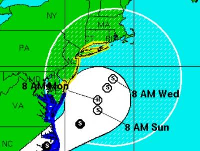
South Fork Under a Tropical Storm Watch Labor Day Weekend

If you were planning on spending your Labor Day weekend outside, you might want to get that out of the way on Saturday, because there is a good chance beaches will be closed to swimming on Sunday, thanks to Tropical Storm Hermine heading our way.
Forecasts are for stormy conditions beginning Saturday. Wind from the northeast is expected to gust to at least 40 miles per hour over the bay and ocean through Tuesday. Rain is likely starting Sunday morning. Calmer conditions will return on Wednesday, with sunny skies and temperatures in the high 70s.
A tropical storm watch has been issued for the area between Sandy Hook, N.J., and Watch Hill, R.I., including Long Island and New York City.
The National Hurricane Center's midday Friday estimate is that Hermine will regain strength as it reaches the Atlantic Coast on Saturday. It expects that Hermine will have hurricane-force winds late Sunday or early Monday, as it churns in the ocean off southern New Jersey.
"We'll be a bit on the edge," East Hampton Town Supervisor Larry Cantwell said on Friday, following a meeting with the town's emergency personnel. "Until we get a better clarification of the track, it's hard to determine with certainty all the impacts we may face," he said, adding that there is good reason to be concerned about beach erosion, high surf, and coastal flooding.
The National Oceanic and Atmospheric Administration is forecasting that with the recent new moon, there is a potential for 3-to-5-foot storm surges during high tides. The Navy and NOAA marine forecast is for wave heights of 12 to 18 feet on the ocean starting Monday afternoon with much higher swells offshore.
The South Fork could see three days of high surf. John Ryan Jr., the chief of the East Hampton lifeguards, said if the forcasts prove to be accurate, beaches will be closed to swimming on Sunday. "The pounding surf is going to be difficult for people to swim in," he said. He is also concerned about Tuesday, after the summer schedule ends and lifeguards are off duty, and he is considering putting lifeguards on duty because of the surf conditions. He cautioned that no one should swim in unprotected waters.
Heavy surf is expected well into next week.
"We're going to continue to communicate as things go, but we're ready," Mr. Ryan said.
A green flag was flying Friday. "It's the calm before the storm," Mr. Ryan said. A yellow flag, meaning caution, will likely fly on Saturday, he said.
"Slow weakening is expected later in the period, but Hermine is expected to remain a dangerous cyclone through five days," Michael Brennan, a senior hurricane specialist at the National Hurricane Center, wrote in a forecast discussion issued at 11 a.m. on Friday.
As of Friday, Hermine's strongest winds extended east about 175 miles from its center.
