Town Eyes Low-Lying Lands

Some of East Hampton Town’s efforts to preserve land have taken a new tack lately, homing in on environmentally sensitive or threatened areas and seeking to prevent development or even remove houses.
One new town initiative follows a state law passed as a result of Superstorm Sandy that authorized the five East End towns, for which the Peconic Bay Region Community Preservation Fund was established, to consider buying property at risk of coastal erosion or flooding in addition to authorized purchases to protect open space, farmland, historic sites, and provide land for parks and recreation.
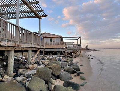
The town recently sent letters to owners of vacant lots surrounding Lake Montauk, where an anti-pollution initiative is ongoing, and residents of two streets in flood-prone Lazy Point, Amagansett, and had received enthusiastic responses from those interested in selling to the town. Within a week of sending letters to 200 owners of lots within the Lake Montauk watershed, said Scott Wilson, the town’s director of land acquisitions and management, 27 had indicated an interest in selling their land. A separate effort to approximately 120 residents of Mulford Lane and Bayview Avenue in Lazy Point also drew numerous positive responses.
While C.P.F. money would be used to make the Montauk purchases, the Lazy Point initiative may get a boost by a grant from a federal floodplain program through the Department of Agriculture’s Natural Resources Conservation Service. It would allow purchases at “pre-storm market values,” and houses would be removed.
“My phone has not stopped ringing since the letters went out,” Kim Shaw, the town’s director of natural resources, who is coordinating the effort in conjunction with the Nature Conservancy, said Tuesday. Seven property owners have already submitted applications, and 20 people have called or emailed for more information. Those Lazy Point residents interested were asked to return a form to the town by Monday, at no obligation, so that a grant application could be submitted by April 18. Ms. Shaw is to meet with a representative of the Mulford Lane homeowners association to discuss the program.
“I think this is a pre-emptive way to deal with problems that we know we’re going to have to deal with in the future,” Town Supervisor Larry Cantwell said this week. “It’s obvious, what’s happening there,” he said of the eroding shores at Lazy Point, citing the example of a house at the end of Mulford Lane that is actually in the water. “The acquisition of land, including some improved properties, for floodplain protection and water quality protection are a key component to solving these issues.”
According to a description in a town memo, the objective is to “protect and restore the natural floodplain and its functions; protect ground and surface water quality; protect open space, scenic vistas, wildlife habitat, dune lands and vegetation; provide public access to the shoreline, and add to the already protected lands in the area owned by New York State (Napeague State Park), the town, and the town trustees.”
While mailings have gone out to residents of only two streets at Lazy Point so far, any private property owner within the targeted area, encompassing all the property east of Napeague Meadow Road, could be eligible to participate. Projected spending for the first phase of the project is $5.25 million, most from the federal grant, if approved. A total of $250,000 would be contributed locally, with $150,000 from the town, probably from its community preservation fund, and a $100,000 contribution from the Nature Conservancy through its coastal resilience buyout program.
The pool of federal money for the grants is over $100 million, Randy Parsons, a conservation finance and policy adviser for the Nature Conservancy, wrote in a memo to town staff. However, Ms. Shaw said this week, numerous communities will be competing. On Long Island, she said, the Mastic-Shirley area, hit hard by storm flooding, is being targeted.
If the town wins the grant and purchases are made through the program, the federal agency would own easements or development rights on the properties, while East Hampton Town would own the underlying land, Mr. Parsons said at a recent town board meeting. But if the federal dollars don’t come through, the town could use the community preservation fund to begin buying properties in coastal floodplains, Mr. Parsons said in his memo.
In his letter to 200 Montauk landowners, Mr. Wilson wrote that “Lake Montauk is under significant stress leading to seasonal closures to shellfishing and swimming.” Because of that, he said in an interview, the undeveloped watershed lands were targeted for purchase with the community preservation fund.
“The evidence indicates the cumulative impact of non-point sources of water quality impairments such as sanitary effluent, fertilizers, the clearing and grading of land, and other changes to the volume or composition of runoff continue to represent a water quality concern for Lake Montauk, as well as other harbors within the town,” Mr. Wilson wrote. By selling their land to the town for preservation, Mr. Wilson wrote, the Montauk property owners “can help ensure that these lands continue to be excellent buffers for the lake, limiting the flow of chemical and natural contaminants.”
Future town efforts will turn to other critical watershed areas, he said, such as those surrounding Accabonac and Three Mile Harbors.
