Trails Gain Acceptance
This is the seventh article in a series examining various aspects of real estate on the South Fork.
The rural experience: a walk in the woods, a meander through the meadow, a stroll on the sand.
Even these are not without controversy on the South Fork, where residents want both privacy and access to unspoiled preserved areas.
East Hampton Town's trail system, when devised in the early '80s, caused a furor among owners of properties adjacent to the new paths, who feared the trails would bring a loss of privacy, decreased property values, and criminal trespassers to their doors.
Now, the woods trails, with names like Devil's Cradle, the Keyhole, and Northwest Path, have wandered into homeowners' hearts, with developers voluntarily including hikers' access in subdivision plans and residents enjoying strolls on nearby paths.
Antagonists
There are still some, though, who are "openly antagonistic," according to the East Hampton Trails Preservation Society, and a healthy strain of "not in my backyard" sentiment lingers.
On North Haven, a 2.5-mile trail on the village-owned Stock Farm Preserve has been disputed for more than a decade, with the homeowners' association of the adjacent development, North Haven Point, threatening a suit to stop trail improvements.
There is wide support for the North Haven trails, said Jeanne Vielbig, president of that village's trails association.
"I think the majority thinks it's an asset," said Fred Stelle, who heads the Village Board's Parks and Recreation Commission. The board recently voted to proceed with a 1.25-mile "loop trail" section.
North Haven
According to Jed Schutz, a member of North Haven Point's board of managers, besides concerns about hikers traversing backyard edges, causing a loss of privacy and raising security worries, the association questions whether a trail should be placed in the fragile wetlands.
The board has cited the presence of ticks, a threat to walkers, on the preserve. Members also contend that a trail is disallowed under the covenants deeding the Stock Farm property from the original subdivision owner to the village.
In recent developments, the owners of four North Haven Point lots have been charged with illegally clearing trees from their property and laying them as barriers across the village trail. Mr. Schutz said the group was "attempting to negotiate a reasonable solution with the village."
Asked if prospective buyers might see the trail as an asset, Mr. Schutz said, "I couldn't conceive of that being a plus."
No More Wagons
Though the ancient East Hampton trails and Trustee roads - originally lumber trails through the woods or paths allowing fishermen to reach the water's edge - were wide enough for a wagon or a horse and rider to pass a walker, the new ones are usually footpaths. They traverse property owned by the town or the county, or easements reserved by developers.
According to New York State law, a municipality may "require land in a subdivision to be reserved for parks and recreation." The law also allows for the protection of "natural features" found on the land, including trails.
In East Hampton, an existing trail cannot be "obliterated" by a developer, but the Planning Board may allow one that interferes with subdivision plans to be rerouted.
Developers Volunteer
The Planning Board does not require developers to create new trails, but often asks for reserved easement areas where they can be placed. Trails are usually cut by members of the East Hampton Trails Preservation Society.
Though the town cannot require a developer to allow public access to a trail across private property, many do so voluntarily, or deed reserved trail areas to the town. Maps of the trail system are available at the East Hampton Town Clerk's office.
The East Hampton segments of the Paumanok Path, a 100-mile system of connected trails from Rocky Point to Montauk, will be sited largely on public land.
Privacy Issues
Issues raised when the town's plans to preserve or create trails were first revealed are still concerns: liability, degradation of the environment, misuse of the trails by motorized vehicles, and public access, which, some homeowners feared, would lead to break-ins, fire, and loss of privacy.
Privacy is a key element for his clients, said Randy Parsons, a private land-use consultant who heads LandMarks in East Hampton. Private land buyers can be deterred by the presence of a trail allowing public access, he asserted.
Though he walks the trails often himself, Mr. Parsons said he "understand[s] that a lot of people really crave privacy," and that those accustomed to city living may have some "paranoia about strangers."
Informed Buyers
Such fears are unfounded, trails proponents insist.
"You couldn't find a nicer bunch of people than hikers, bikers, and horseback riders," declared Richard Lupoletti, president of the Trails Preservation Society.
According to Rick Whalen, a deputy town attorney and a trails advocate, "what we feared 10 to 15 years ago - that trails would be a potential problem, opposed by neighbors - turned out not to be the case at all." In fact, he said, the extent to which trails have been accepted is "remarkable."
For prospective buyers of land or homes abutting trails, "it's an unknown, so they're a little leery," said Mike DeSario, a broker at Cook Pony Farm in East Hampton who specializes in land sales and development.
When people become informed, learning where trails are, who uses them, and that motorized vehicles are not allowed, they "okay it," he said.
Liability
Liability is another concern. According to New York State law, said Mr. Whalen, property owners are not liable for "ordinary negligence" when their land is used by the public for recreational purposes. The only instance in which a landowner may be considered liable, he said, is if he or she has committed a "willful or malicious act" that results in an injury.
But Mr. Parsons said landowners continue to worry about having to defend themselves against a suit.
David Weaver, a surveyor at Walbridge Associates in East Hampton, agreed. In his experience, many land buyers seeking privacy "don't like having a trail near them." Mr. Weaver often represents Northwest property owners and land developers before the Planning Board.
He specifically looks for trails when surveying tracts. If one is found, "we work around it," he said. "As long as the Planning Board is willing to accept relocation [of a trail], which they almost always have in past years, it doesn't pay for the developer not to cooperate."
Subdivision design has evolved over the years, said Mr. Whalen, to include more open space.
Land developers here are "sophisticated," said Mr. DeSario. "They realize that people come here because it's beautiful, and if they destroy that, they won't come."
In fact, trails have come to be considered a "recreational asset," Mr. Whalen said.
In fact, he added, several 1980s developments, including Wildflower Woods, off Hog Creek Road in Springs, and Cedar Trails in East Hampton used the inclusion of trails as a selling point.
Public Acceptance
Better planning early in the development process, including careful provisions for a buffer zone between trails and houses, has alleviated some of the early problems and complaints, Mr. Whalen said.
And, he said, a changing public attitude toward recreation, with greater awareness of trails and more and more people using them, has contributed to their acceptance.
The Trails Preservation Society, which counts 225 memberships, last year led 1,200 people on more than 90 guided hikes, according to Mr. Lupoletti.
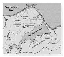
The areas with the most extensive trail systems adjacent to houses are in Northwest and Springs.
"We're finding that people who live in those areas are the ones using the trails," Mr. Whalen said.
Before Is Better
Homeowners in the Landfall and North Woods subdivisions in Northwest were vociferously opposed to the creation of the first trails, within sight of their properties.
"The trick is people knowing about it from the beginning," said Mr. DeSario. "For the most part, I find that if it's presented accurately - that there's a trail and on a busy weekend you may see six people going by - most people are comfortable with it."
Creating a trail over an existing piece of property is a different story, though planners "almost never do that," he said.
Although most trail easements are already in place and buyers are informed of them before purchase, objections are sometimes raised when a trail is cut through woods homeowners have formerly had all to themselves.
"We're aware of the fact that it's a much better business to cut the trail before a homeowner moves in," said Mr. Lupoletti.
Adequate Buffers
"One way of making trails fit into a residential community is to make sure there's an adequate buffer," Mr. Whalen said.
The lack of such a buffer is the cause of a suit against the town brought by a Bull Path resident whose house was built facing a 20-foot-wide sliver of land which the town later purchased for a trail.
"None of our trails impinge on anyone's private property," said Mr. Lupoletti. "When that takes place, we move the trail."
A spirit of compromise helped resolve a situation that arose this year in Northwest, where a section of the Old Camp Road segment of the Northwest Path was moved after two residents whose land it crossed complained they were disturbed by mountain bikers using the trail.
"We don't want to impact anybody adversely," said Mr. Lupoletti.
The trail system is "part of what I feel the town has done to keep this area beautiful and to allow people to enjoy the beauty," Mr. DeSario said. Ultimately, he said, that was good for the real estate market.