Wind Cable Doubts

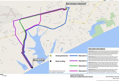
Technical aspects and proximity to the Long Island Power Authority’s substation on Cove Hollow Road in East Hampton make Beach Lane in Wainscott an excellent potential landing site for the transmission cable that would run from the proposed offshore South Fork Wind Farm, officials of Deepwater Wind told members of the Wainscott Citizens Advisory Committee’s environmental subcommittee on Monday morning at Town Hall.
Some members of that committee were unconvinced, however, wondering aloud if other considerations led Deepwater Wind, the Rhode Island company that seeks to develop the wind farm, to that conclusion.
Deepwater Wind officials had briefed the committee in August, and modified their proposal based on feedback received, said Paul Murphy, the company’s vice president for engineering and operations. The Beach Lane site is one of three oceanside landings to be considered after an initial plan to run the transmission cable through Gardiner’s Bay was vociferously opposed by commercial fishermen.
Aram Terchunian of First Coastal, a Westhampton Beach consulting and contracting company, spoke on behalf of Deepwater Wind. Wainscott lies in Long Island’s “coastal ponds” region, he said, its topography typically composed of geologically recent sediments. “They’re pretty soft and squishy,” he said of coastal pond areas, describing “sand and gravel down to silt and mud.”
Sand deposits are a relatively thin overlay atop underlying glacial soils, according to a PowerPoint slide Mr. Terchunian displayed. These soils are significantly less likely to erode than overlying sand, it read.
The geology of the beach has been studied over the last 80 years, Mr. Terchunian said, indicating a hard bottom at Beach Lane. This was important, because “if you’re going to bury a conduit, how deep should you bury it so it doesn’t get exposed?”
The beach is a veneer that lies on top of the mainland, he said. “But it’s this veneer, this blanket of sand moving vertically and horizontally on top of what is more or less a fixed surface.” Those 80 years of study, he said, demonstrate that the transmission cable, run through a plastic conduit beginning approximately 1,500 feet offshore, would never be exposed by extreme weather events.
Simon Kinsella, the environmental committee’s chairman, disputed Mr. Terchunian’s conclusions. The 80 years of study cited feature just 18 snapshots, he said, and do not include 2012, the year of Hurricane Sandy. “You’re telling me it’s complete,” he said to Mr. Terchunian of his data. “I’m telling you it’s not complete,” he said, distributing photographs of the beach in Sandy’s aftermath. “It makes me nervous, the fact that it was deliberately left out. . . . It’s not going to hold up when large chunks of cement are being tossed around. . . . I just don’t have confidence in your numbers.”
“When you talk about change using aerial photographs, this is only the visual change you see when you go to the beach,” Mr. Terchunian answered. “Profile data,” comprising measurements of the underlying soil from the backside of the dune through the surf zone and bar systems to the depth of closure, where waves cease to move sediment, “give us a complete picture from what you see visually and what you don’t see in the submarine area, which is oftentimes more important.”
Why isn't Main Beach under consideration for the cable’s landfall site, the Deepwater officials were asked, with one member of the committee suggesting that the location was driven less by geography than “pushback that’d come from the laid-back farm boys” of Wainscott rather than “the aggressive billionaires on Lily Pond Lane.”
The street is narrower near Main Beach, said Jennifer Garvey, Deepwater Wind’s Long Island development manager, with “some turns as we get to Cove Hollow Road . . . in a very public, high-traffic area.” Upon examination, a Wainscott landing “would be easier for us to accommodate on the overland route.” Per Deepwater Wind’s contract with LIPA, the cable has to plug into the substation at Cove Hollow Road, she said, and not the Amagansett substation, a suggestion Mr. Kinsella had made.
Mr. Murphy said that based on feedback from the Wainscott C.A.C., an initially proposed work area in the parking lot at the end of Beach Lane had been abandoned in favor of a narrow strip on the lane itself, a few hundred feet back from the road’s end. The work area would occupy one traffic lane and the shoulder of the road, allowing a lane of traffic, with no impact on parking or access to the beach.
Deepwater Wind plans to submit applications to multiple federal and state permitting agencies early next year. Should all go according to plan, this construction would happen in the winter of 2021 and take approximately 14 weeks, Mr. Murphy said. The cable itself would be pulled through the conduit over approximately one week between the months of March and May. The road would then be restored and repaved.
On Monday evening at Town Hall, Rick Drew of the East Hampton Town Trustees' harbor management committee recommended that Deepwater Wind officials, at the trustees' Dec. 11 meeting, present their environmental findings with respect to the Block Island Wind Farm, which it built and began operating last December. The harbor management committee has held a series of meetings focused on the South Fork Wind Farm plan, which is of great concern to commercial fishermen. Deepwater Wind officials would also present conclusions of pre-construction survey work of the South Fork Wind Farm site, Mr. Drew said.
Noting “a lot of anticipation” for the presentation, Mr. Drew said that the trustees' meeting place, at Town Hall, would provide the best forum. The trustees will begin their meeting a half-hour earlier than usual, at 6 p.m., to accommodate Deepwater Wind’s presentation in addition to their regular agenda.
