
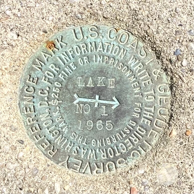
Number one — stamped “Lake No. 1” — can be found on Montauk Highway not far from Kirk Park, just west of downtown Montauk: a faded-green bronze disk, the easternmost of the many U.S. Coast and Geodetic Survey Reference Marks placed around the South Fork in 1965 by the U.S. Coast and Geodetic Survey, now known as the National Geodetic Survey.
The bronze markers from 1965 can be found across the South Fork in varying condition. Locating them can be a scavenger hunt, of sorts. Hands off, though: a $250 fine or imprisonment is the penalty for tampering.
The U.S. Coast and Geodetic Survey began putting down markers in various materials — earthenware, glass bottles, stone, metal — more than 200 years ago as fixed markers for topographic and hydrographic mapping that would aid safe navigation of the coastline. There are now more than 1.5 million markers around the country.
Daniel Winester, a geodesist at the N.G.S., told East about the marks, also known as “reference stations,” over email: “Triangulation uses the angles measured between stations and a known distance to build up a network of stations of calculated longitudes and latitudes using the Law of Sines,” he said. In other words, a network is built using the angles measured between these stations. It’s just geometry.
William Walsh, a Montauk-based surveyor with a vast knowledge of local history, said that he has used the marks many times to aid in surveying, despite the invention of the GPS. The kind of surveying done by Walsh can be used for determining ownership boundaries for property sales and other mapping. The N.G.S. marks are a “handy reference,” Walsh said. “In survey work, history is important. Original surveyors in the 1920s and 1930s were using government geodetic markers. They started using these markers and went on using a very different coordinate system. We use both systems interchangeably.”
Walsh explained that the central arrow on the “Lake No. 1” Montauk reference mark points to a “main station” that, according to the N.G.S. website, is precisely 87.96 feet away. Another reference mark is nearby, but a third, the “Azimuth Station,” was destroyed in a development project.
Scavenger hunters note: The marker for a main station is distinguished from that for a reference station by a triangle at its center.
“GPS does not replace the usefuness of old systems,” Walsh said. And this system is, most certainly, old. President Thomas Jefferson founded the Survey of the Coast as the nation’s first civilian science agency in 1807. A Swiss-American scientist named Ferdinand Hassler, also remembered as the grandfather of the National Oceanic and Atmospheric Administration, was appointed its first superintendent.
Despite changes in technology, Hassler’s geodetic triangulation system is still the basic method used by NOAA surveyors. Nowadays, the survey is part of the National Oceanic and Atmospheric Administration’s National Ocean Service.
“The original purpose was to map the coastline for shipping,” Walsh said, noting that East Hampton Town possesses a copy of a map from one of the original coastal surveys in 1838.
While the brass “Lake No. 1” may be the easternmost marker in town, what is the oldest geodetic mark in East Hampton? It’s hard to say. “The Montauk Point Lighthouse was used in surveys as early as 1882,” Winester, having browsed N.G.S. archives, said, “The Little Gull Island Lighthouse was used in 1874.” However, a still-intact geodetic mark from 1943 sits just south of Town Pond in East Hampton Village.
As for the present, the scavenger hunt is not, in fact, just a joke. The United States Power Squadrons take it quite literally, running a recovery program for geodetic marks. Once “recovered” — located, that is — members report the marks to the N.G.S. using a date-stamped photograph. “Some of them get buried over time,” said Thomas Peltier, the cooperative charting chairperson for the Power Squadron’s Long Island branch. He described the program as “an activity for our members to keep busy.” At present, about 164 members of the Long Island group participate in the geodetic-marker program.
The hunt doesn’t end at the East River, either, of course. Peltier mentioned that members have recovered lost marks while on vacation, braving the elements and many types of terrain to do so. One group, he said, got stopped crossing a cemetery with shovels, in their enthusiasm blithely unaware of the optics. We’re not gravediggers, they clarified, just hunting for geodetic marks.