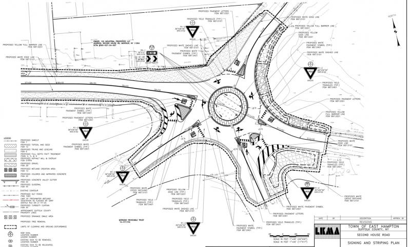
A long-discussed plan to alleviate chronic flooding and improve safety by constructing a traffic circle at the five-way intersection between Fort Pond and Fort Pond Bay in Montauk was a last-minute addition to the agenda at Tuesday’s meeting of the East Hampton Town Board. The plan involves raising the intersection by around eight inches.
No timetable for the project, which a consulting engineer said would take three to four months, was announced, but one adjacent property owner asked the board that it not be constructed during the tourist season.
“The roadway is at very low elevation, very flat,” Jim Peterman of L.K. McLean Associates said of the intersection where Second House Road and Industrial Road see the majority of vehicle traffic, but which also includes Midland Road and North Shore Road, with the elevated Long Island Rail Road tracks nearby as well. Drainage “is very difficult,” also owing to high groundwater and an abundance of underground utility infrastructure. “In my 40 years of experience, I never had an intersection with the amount of underground facilities that they have out here,” he said.
Starting just west of the railroad tracks, “there will be an asphalt roadway resurfacing,” Mr. Peterman said, “with some good amount of fill at some locations to give it a constant pitch toward the new traffic circle.” The plan calls for drains, basins, and multiple bioswales to filter stormwater before it reaches Fort Pond, which is ecologically compromised.
Mr. Peterman and Councilman David Lys, who is the liaison to the Montauk Citizens Advisory Committee, described a network of pipes that would move water from one bioswale to another. The New York State Department of Environmental Conservation, which has issued required permitting for the project, has also stipulated that native vegetation be included, Mr. Peterman said.
Along with the traffic circle, the plan calls for a steel-backed, wood timber guardrail along the pond. An existing utility pole would remain inside the traffic circle, and two others would have to be moved. PSEG Long Island “knows what’s coming,” he said of the utility that manages the electrical grid on the Long Island Power Authority’s behalf. “They have no issues with it.”
The drainage improvements notwithstanding, “we should not expect this plan to alleviate all flooding events,” Supervisor Peter Van Scoyoc said, referring to the intense rainfall that, along with sea level rise, is a manifestation of climate change. A similar redesign and reconstruction effort around the nearby L.I.R.R. station and the Rough Riders Landing condominiums “helped significantly with regular rainfalls,” he said, but in a large rainfall, “it’s not going to alleviate flooding for those periods of time.”
“During a super-intense event, will you have ponding issues until it goes down? Most likely,” Mr. Peterman agreed. “However, soon after it will all get drained out. . . . Right now, the way the road sits, it’s designed like a bathtub. The water has nowhere to go.”
Regarding the traffic circle, “it’s a confusing intersection,” Mr. Van Scoyoc said, echoing the adjacent property owner, Jim Grimes, who noted that there have been several accidents in the area. “This will also aid with the improvement of traffic safety and a more orderly entrance and exiting of that five-armed intersection,” the supervisor said.
Along with urging an off-season time frame, Mr. Grimes, who owns a landscape design firm, said he and his neighbors would like assurance that the plan “will actually be functional both as a drainage project and as a traffic flow project.” Construction of a nearby PSEG facility cost him and two other commercial entities “thousands of dollars in lost time and inconvenience down there,” he said. “I really would not hope that we have a replay of that.”


