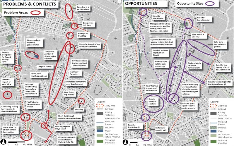
In the area the East Hampton Town Board is calling the Springs-Fireplace Corridor — between the village and the hamlet of Springs — consultants looking at traffic, land use, and environmental issues have identified a number of opportunities to improve longstanding problems while also planning for future development.
The corridor is bounded on the south by the intersection of North Main Street, Three Mile Harbor Road, and Springs-Fireplace Road, on the north by Abraham’s Path, on the west by Three Mile Harbor Road, and on the east by Accabonac Road from Abraham’s Path to Floyd Street.
Not only does it contain commercial-industrial uses important to the town’s economy and a town recycling center, but it also includes some of the most heavily-trafficked intersections in the town outside of Route 27.
Ray DiBiase, one of the consultants who briefed the town board on their evaluations of the area Tuesday, discussed four “critical” intersections: the oft-congested North Main Street-Three Mile Harbor Road-Springs-Fireplace Road nexus, which he said sees 80 percent of the traffic in and out of the study area; the intersection of Three Mile Harbor Road and Abraham’s Path, and the north and south intersections of Abraham’s Path and Springs-Fireplace Road.
While the consultants suggested a roundabout at the North Main Street-Three Mile Harbor Road-Springs-Fireplace Road intersection, construction would be very expensive and require encroachment on the triangular property between Three Mile Harbor Road and Springs-Fireplace Road, preserved parkland that would require parkland alienation at the New York State level. Further, a Suffolk County project to widen Three Mile Harbor Road is slated for 2026, which could accommodate turning lanes and a bicycle lane in either direction, eliminating the need to encroach on public parkland. The consultants recommend that the town ask the Suffolk County Department of Public Works to add those extra lanes when it widens the road. As it did when widening Springs-Fireplace Road, the county should provide continuous sidewalks on one side of Three Mile Harbor Road, Mr. DiBiase said.
Adding westbound left and right turning lanes on Abraham’s Path at its intersection with Three Mile Harbor Road, where a single lane now exists, has been forwarded to the county for inclusion in its project, he said. The county’s recent widening of a stretch of Springs-Fireplace Road has improved conditions there, Mr. DiBiase said, so recommended roundabouts at each of its intersections with Abraham’s Path have been put on hold.
Mr. DiBiase said the town should also investigate paving Washington Avenue, a C-shaped street off Springs-Fireplace Road, south of Tan Bark Trail, and relocating driveways from Springs-Fireplace Road to Washington Avenue where feasible. There are 10 parcels in the .1-mile stretch of Springs-Fireplace between the two ends of Washington Avenue, almost every one with its own driveway.
He also suggested improving drainage at chronic flooding locations on Floyd Street.
After the county’s improvement of Three Mile Harbor Road, Abraham’s Path should be widened to 28 feet and a bicycle route added between Three Mile Harbor Road and Springs-Fireplace Road to connect bicycle lanes on Springs-Fireplace north of Abraham’s Path with those the county would install on Three Mile Harbor Road, Mr. DiBiase said.

The study began shortly before the Covid-19 pandemic forced a shutdown of normal activity, impeding its progress. Its key goals are to evaluate the cumulative impacts of ongoing and projected buildout under the current zoning code and recommend ways to improve the functional and aesthetic character of the area while reducing environmental threats.
Feedback from a February 2020 workshop included an emphasis on protecting water quality, Lisa Liquori, another consultant, told the town board. Those who attended the workshop also acknowledged that commercial-industrial uses in the area are important, and that retaining the existing residential neighborhood and scenic and historic resources are also important. There was support for physical improvements and integrating pedestrian connections and green space with the surrounding areas, she said.
There are about 275 acres of developable land in the study area, Peter Flinker, another consultant, said of future growth potential. This comprises 182 parcels ranging from 2,000 square feet to 62 acres, though all but 13 of them are fewer than two acres. “The lion’s share of development potential is in the large gravel pits” on Springs-Fireplace Road, he said.
On a theoretical 120-acre site — more than five million square feet — current zoning limits its buildout to 50 percent for building coverage and 75 percent as lot coverage, he said. Looking at access, topography, and other considerations, “we estimated that there’s the potential for 1.75 million square feet of development within the commercial-industrial zone.” That was the basis for estimating future traffic demand, he said.
Ms. Liquori suggested rezoning a portion of developable commercial-industrial land for affordable housing. The town could also develop a “clean industry” zoning district “to provide a fair return on the land” while limiting uses to low sanitary flow, solid waste production, and traffic generation, and low or no handling of toxic or hazardous chemicals. As an example, she suggested the reuse of some of the sand and gravel mining land as a solar farm, which would not require the clearing of woodlands.
The zoning code could also be amended to reduce maximum building coverage from 50 percent to 15 or 20 percent in commercial-industrial zones, she said.
Along Springs-Fireplace Road in particular, for aesthetic purposes, “we recommend a combination of opaque hedges and fences” where none exist, Mr. Flinker said. “Over all, one of the things we realized is there’s so many curb cuts, it’s difficult to screen all of it.” If they could be consolidated, there would be fewer views into industrial and other commercial parcels, he said. Site planning standards could be modified for landscaping and screening, and public-private partnerships could increase tree planting and improve landscape management.
To protect ground and drinking water, Ms. Liquori said that a registry for toxic and hazardous materials should be developed. The town board is in the process of drafting legislation for groundwater monitoring for mining, she noted. “As a leader in environmental protection, the town is encouraged to establish a pilot demonstration project applying best management practices for organic mulching facilities.”
Jeremy Samuelson, director of the Planning Department, said at the presentation’s conclusion that residents with questions about the consultants’ recommendations should contact his department. “Now is the time for the public to offer their own thoughts for analysis and consideration,” he said. “This is an invitation to share your concerns.”


