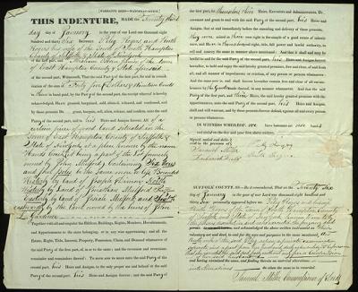
Deed From Rogers to Osborn, 1836

The East Hampton Library’s Long Island Collection doesn’t have any village maps showing individual homeowners or property lines before 1858 or even 1873 for most of the East End, which can be tricky when we are asked to identify where someone used to live.
There are, however, many deeds and wills available in the collection, and they frequently describe both the property being transferred and the name of the adjoining property owners.
The deed shown here, from Jan. 23, 1836, transfers land in East Hampton from two Southampton residents, Peleg and Ruth Rogers, to Aaron Osborn Jr., an East Hampton resident. While we don’t know exactly which lot this was, the deed provides a general description of the property’s location, along with a list of property owners.
The land is described as a six-acre “woodland” lot “at Hands Creek.” Hand’s Creek lies to the west side of Three Mile Harbor, placing this land somewhere in what is now known as Northwest Woods. The property lines are bound “westerly by land of Joseph Dimon, northwesterly by land of Jonathan Mulford Jr., easterly by land of Josiah Mulford, and southeastwardly by the land owned by the heirs of John L. Gardiner.”
Within 40 years of the time this deed was written, published atlas pages would begin to name property owners and mark where houses stood for the residents of East Hampton’s Northwest Woods. The deed itself hints at the advances in printing technology and the gradual transitions to modern records. Large portions of the text of the deed are pre-printed, such as the itemized list of property rights a seller relinquishes. The pre-printed text is paired with blank lines for unique details, such as the property description and the owners’ names. Even the date was printed, leaving space for the day, month, and the last digit of the year.
Andrea Meyer is a librarian and archivist in the East Hampton Library’s Long Island Collection.
