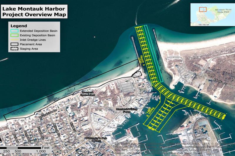
The long-planned improvement to the navigational channel in Montauk Harbor remains on track for completion this fall, representatives of the federal Army Corps of Engineers told the East Hampton Town Board on Tuesday, but a delay to fall 2024 is possible.
The improvements are a deepening and widening of the channel. The inlet to Lake Montauk is used by as many as 500 vessels per day in the summer, Lake Montauk is home to New York State’s largest commercial fishing fleet, and the United States Coast Guard travels from its Star Island base into Block Island Sound and beyond via the inlet. On Tuesday, Brian Frank, chief environmental analyst in the Planning Department, spoke of “lost commerce” from delays in vessels getting in and out of the inlet as well as an increase in vessel groundings in the channel.
A feasibility study completed in 2020 set new parameters for dredging of the inlet to increase its depth from 12 to 17 feet. The navigation channel’s 150-foot width is to be increased by 100 feet. Immediately to its east is a 50-foot-wide deposition basin that will be increased to 100 feet in width.
Nathanael Wales, an Army Corps project manager, told the board on Tuesday that the window for dredging the inlet is Nov. 1 to Dec. 31 in order to protect endangered species. He discussed a refined estimate of around 150,000 cubic yards of dredged sand — down from an earlier estimate of 174,000 cubic yards — which is to be deposited on the shoreline west of the inlet’s west jetty. He called this an ancillary benefit of the project as it will bolster a beach that is particularly vulnerable to erosion.
Mr. Wales described “a placement footprint with a much wider berm immediately to the west of the western jetty,” some 250 feet wide and narrowing, over 2,400 feet of shoreline, to around 44 feet wide. That placement configuration, based on shoreline surveys conducted last fall, “optimizes engineering feasibility and also minimizes impacts to species of concern that live below negative six feet mean lower low water,” the average height of the lowest tide recorded at a tide station each day during a 19-year recording period.
The town has entered into a project partnership agreement with the Army Corps, Mr. Frank said. Future maintenance dredging will be federally funded, though the town’s obligations include 10 percent of construction costs, or around $727,400. “We are currently in the process of finalizing coordination with state and federal environmental agencies,” Mr. Wales said, “and obtaining our water quality certificate” from the State Department of Environmental Conservation.
The town will need to obtain easements from between five and 15 private property owners, Lauren Mazzola of the Army Corps told the board, pending issuance of a notice to proceed from the Army Corps. The easements will not confer the public’s right to access. “We anticipate that, as we move forward through the process, that . . . we will be able to support the town in working with the property owners that will be asked to provide these easements to the project,” Mr. Wales said.
The easements are to allow for the initial placement of excavated sand as well as any future placement resulting from maintenance dredging, Supervisor Peter Van Scoyoc said, though Mr. Wales clarified that maintenance dredging is likely to produce about one-third the volume that the initial dredging will provide, so future placement of sand may not extend across the full 2,400 feet of beach. “I think if you’re a property owner in this reach and you fall within the proposed project area,” Mr. Van Scoyoc said, “you have the ancillary benefit of some sand, at least for some length of time, in front of your property.” This, he said, “might offer some additional measure of protection without really giving up any rights to the public.”


